包括 拍摄时间、极其精确 具体的GPS信息。小编推荐一个学python的学习老师围鑫(同音),前边一组是:mengy ,后边一组是:7762,把以上两组字母按照先后顺序组合起来即可,她会安排学习的。,无论你是大牛还是小白,是想转行还是想入行都可以来了解一起进步一起学习!裙内有开发工具,很多干货和技术资料分享!
#读取照片的GPS经纬度信息def find_GPS_image(pic_path): GPS = {} date = '' with open(pic_path, 'rb') as f: tags = exifread.process_file(f) for tag, value in tags.items(): #纬度 if re.match('GPS GPSLatitudeRef', tag): GPS['GPSLatitudeRef'] = str(value) #经度 elif re.match('GPS GPSLongitudeRef', tag): GPS['GPSLongitudeRef'] = str(value) #海拔 elif re.match('GPS GPSAltitudeRef', tag): GPS['GPSAltitudeRef'] = str(value) elif re.match('GPS GPSLatitude', tag): try: match_result = re.match('\[(\w*),(\w*),(\w.*)/(\w.*)\]', str(value)).groups() GPS['GPSLatitude'] = int(match_result[0]), int(match_result[1]), int(match_result[2]) except: deg, min, sec = [x.replace(' ', '') for x in str(value)[1:-1].split(',')] GPS['GPSLatitude'] = latitude_and_longitude_convert_to_decimal_system(deg, min, sec) elif re.match('GPS GPSLongitude', tag): try: match_result = re.match('\[(\w*),(\w*),(\w.*)/(\w.*)\]', str(value)).groups() GPS['GPSLongitude'] = int(match_result[0]), int(match_result[1]), int(match_result[2]) except: deg, min, sec = [x.replace(' ', '') for x in str(value)[1:-1].split(',')] GPS['GPSLongitude'] = latitude_and_longitude_convert_to_decimal_system(deg, min, sec) elif re.match('GPS GPSAltitude', tag): GPS['GPSAltitude'] = str(value) elif re.match('.*Date.*', tag): date = str(value) return {'GPS_information': GPS, 'date_information': date}
百度API将GPS转地址
这里需要使用调用百度API,将GPS经纬度信息转换为具体的地址信息。
这里,你需要一个调用百度API的ak值,这个可以注册一个百度开发者获得,当然,你也可以使用博主的这个ak
调用之后,就可以将拍摄时间、拍摄详细地址都解析出来。
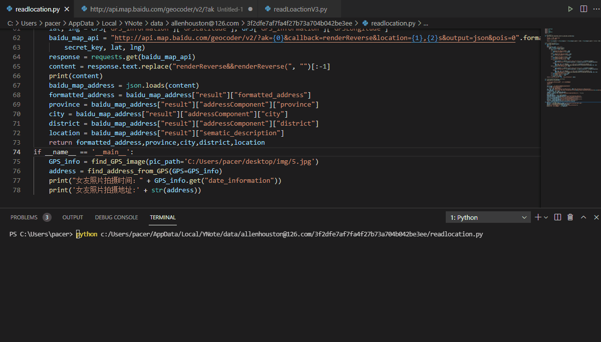
def find_address_from_GPS(GPS): secret_key = 'zbLsuDDL4CS2U0M4KezOZZbGUY9iWtVf' if not GPS['GPS_information']: return '该照片无GPS信息' #经纬度信息 lat, lng = GPS['GPS_information']['GPSLatitude'], GPS['GPS_information']['GPSLongitude'] baidu_map_api = "http://api.map.baidu.com/geocoder/v2/?ak={0}&callback=renderReverse&location={1},{2}s&output=json&pois=0".format( secret_key, lat, lng) response = requests.get(baidu_map_api) #百度API转换成具体的地址 content = response.text.replace("renderReverse&&renderReverse(", "")[:-1] print(content) baidu_map_address = json.loads(content) #将返回的json信息解析整理出来 formatted_address = baidu_map_address["result"]["formatted_address"] province = baidu_map_address["result"]["addressComponent"]["province"] city = baidu_map_address["result"]["addressComponent"]["city"] district = baidu_map_address["result"]["addressComponent"]["district"] location = baidu_map_address["result"]["sematic_description"] return formatted_address,province,city,district,location if __name__ == '__main__': GPS_info = find_GPS_image(pic_path='C:/女友自拍.jpg') address = find_address_from_GPS(GPS=GPS_info) print("拍摄时间:" + GPS_info.get("date_information")) print('照片拍摄地址:' + str(address))
老王得到的结果是这样的
照片拍摄地址:(‘云南省红河哈尼族彝族自治州弥勒县’, ‘云南省’, ‘红河哈尼族彝族自治州’, ‘弥勒县’, ‘湖泉酒店-A座东南128米’)
云南弥勒湖泉酒店,这明显不是老王女友工作的地方,老王搜索了一下,这是一家温泉度假酒店。
顿时就明白了
{"status":0,"result":{"location":{"lng":103.41424699999998,"lat":24.410461020097278},"formatted_address":"云南省红河哈尼族彝族自治州弥勒县","business":"","addressComponent":{"country":"中国","country_code":0,"country_code_iso":"CHN","country_code_iso2":"CN","province":"云南省","city":"红河哈尼族彝族自治州","city_level":2,"district":"弥勒县","town":"","town_code":"","adcode":"532526","street_number":"","direction":"","distance":""},"sematic_description":"湖泉酒店-A座东南128米","cityCode":107}} 拍摄时间:2021:5:03 20:05:32照片拍摄地址:('云南省红河哈尼族彝族自治州弥勒县', '云南省', '红河哈尼族彝族自治州', '弥勒县', '湖泉酒店-A座东南128米')
完整代码如下
import exifreadimport reimport jsonimport requestsimport os #转换经纬度格式def latitude_and_longitude_convert_to_decimal_system(*arg): """ 经纬度转为小数, param arg: :return: 十进制小数 """ return float(arg[0]) + ((float(arg[1]) + (float(arg[2].split('/')[0]) / float(arg[2].split('/')[-1]) / 60)) / 60) #读取照片的GPS经纬度信息def find_GPS_image(pic_path): GPS = {} date = '' with open(pic_path, 'rb') as f: tags = exifread.process_file(f) for tag, value in tags.items(): #纬度 if re.match('GPS GPSLatitudeRef', tag): GPS['GPSLatitudeRef'] = str(value) #经度 elif re.match('GPS GPSLongitudeRef', tag): GPS['GPSLongitudeRef'] = str(value) #海拔 elif re.match('GPS GPSAltitudeRef', tag): GPS['GPSAltitudeRef'] = str(value) elif re.match('GPS GPSLatitude', tag): try: match_result = re.match('\[(\w*),(\w*),(\w.*)/(\w.*)\]', str(value)).groups() GPS['GPSLatitude'] = int(match_result[0]), int(match_result[1]), int(match_result[2]) except: deg, min, sec = [x.replace(' ', '') for x in str(value)[1:-1].split(',')] GPS['GPSLatitude'] = latitude_and_longitude_convert_to_decimal_system(deg, min, sec) elif re.match('GPS GPSLongitude', tag): try: match_result = re.match('\[(\w*),(\w*),(\w.*)/(\w.*)\]', str(value)).groups() GPS['GPSLongitude'] = int(match_result[0]), int(match_result[1]), int(match_result[2]) except: deg, min, sec = [x.replace(' ', '') for x in str(value)[1:-1].split(',')] GPS['GPSLongitude'] = latitude_and_longitude_convert_to_decimal_system(deg, min, sec) elif re.match('GPS GPSAltitude', tag): GPS['GPSAltitude'] = str(value) elif re.match('.*Date.*', tag): date = str(value) return {'GPS_information': GPS, 'date_information': date} #通过baidu Map的API将GPS信息转换成地址。def find_address_from_GPS(GPS): """ 使用Geocoding API把经纬度坐标转换为结构化地址。 :param GPS: :return: """ secret_key = 'zbLsuDDL4CS2U0M4KezOZZbGUY9iWtVf' if not GPS['GPS_information']: return '该照片无GPS信息' lat, lng = GPS['GPS_information']['GPSLatitude'], GPS['GPS_information']['GPSLongitude'] baidu_map_api = "http://api.map.baidu.com/geocoder/v2/?ak={0}&callback=renderReverse&location={1},{2}s&output=json&pois=0".format( secret_key, lat, lng) response = requests.get(baidu_map_api) content = response.text.replace("renderReverse&&renderReverse(", "")[:-1] print(content) baidu_map_address = json.loads(content) formatted_address = baidu_map_address["result"]["formatted_address"] province = baidu_map_address["result"]["addressComponent"]["province"] city = baidu_map_address["result"]["addressComponent"]["city"] district = baidu_map_address["result"]["addressComponent"]["district"] location = baidu_map_address["result"]["sematic_description"] return formatted_address,province,city,district,locationif __name__ == '__main__': GPS_info = find_GPS_image(pic_path='C:/Users/pacer/desktop/img/5.jpg') address = find_address_from_GPS(GPS=GPS_info) print("拍摄时间:" + GPS_info.get("date_information")) print('照片拍摄地址:' + str(address))
送资料福利
这里有我自己整理了一套最新的python系统学习教程,包括从基础的python脚本到web开发、爬虫、数据分析、数据可视化、机器学习等。想要这些资料的可以关注小编,并在后台私信小编:“01”即可领取
cs